
What Can Brookhaven Actually “Tweak” At Windsor Parkway?
What the project plans, GDOT guidance, right-of-way boundaries, underground infrastructure, and budget documents tell us about the next round of review.

The Windsor Parkway and Ashford Dunwoody Road project is paused while Brookhaven gathers more information about tree impacts and consults with the Georgia Department of Transportation.
Councilmember John Funny asked the City to work with GDOT on possible design “tweaks” roughly a week before Councilwoman Madeleine Simmons announced that the Council had voted to pause the project. The word tweak now carries a lot of weight. It could mean narrowing a path in a constrained location, moving a curb, reducing grading, modifying a stormwater structure, narrowing travel lanes, or shifting part of the roadway to preserve a significant tree. It is also being used to describe a much larger change: removing the shared-use path on the south side of Windsor Parkway and providing no sidewalk in its place.
Those are not the same kind of design change.
I did not believe a formal pause was necessary. Construction was not expected to begin until 2027, leaving time for the City to complete a tree inventory, consult with GDOT, clarify the budget, and evaluate potential design changes without interrupting the project’s progress. But now that the Council has paused it, the City should use that time wisely to answer a key question clearly:
Which impacts can be reduced without abandoning the safety, pedestrian, and bicycle functions the project was designed to provide?
Three Things You Need To Know
What Happened: Brookhaven paused the project, and Councilmember Funny asked the City and GDOT to examine possible design tweaks.
Why Residents Are Concerned: The project affects mature trees, landscaping, portions of nearby properties, and a corridor many residents experience as a wooded residential road.
What Has Not Been Proven: The public has not yet been shown which trees, right-of-way needs, construction impacts, or costs would actually disappear if the shared-use path, sidewalk, roadway alignment, or other project features were changed.
The project footprint is not made up only of pavement, paths, and trees. It must also accommodate the road itself, curb and gutter, grading, stormwater pipes, drainage structures, retaining walls, utility relocations, and construction access.
Before anyone promises that a particular change will save particular trees or reduce the cost by a particular amount, the City should show which project element is causing each impact.
How This Analysis Was Conducted
I am not a traffic engineer, and this article is not an engineering review of the final construction plans. It compares the publicly available concept layouts and typical sections with GDOT’s Roundabout Design Guide, GDOT’s Pedestrian and Streetscape Guide, the adopted 2024 Brookhaven Multimodal Study, City utility and stormwater mapping, and the budget documents currently available to the public.
Where a plan or guide provides a direct answer, I quote or closely paraphrase the document.
Where those documents suggest a possible constraint or design option, I identify that as an inference.
Only Brookhaven’s engineers and GDOT can determine whether a particular change is geometrically, operationally, financially, or legally feasible. The goal here is not to select a preferred redesign, but to clarify what the available plans and guidance do—and do not—establish before the City presents possible alternatives.
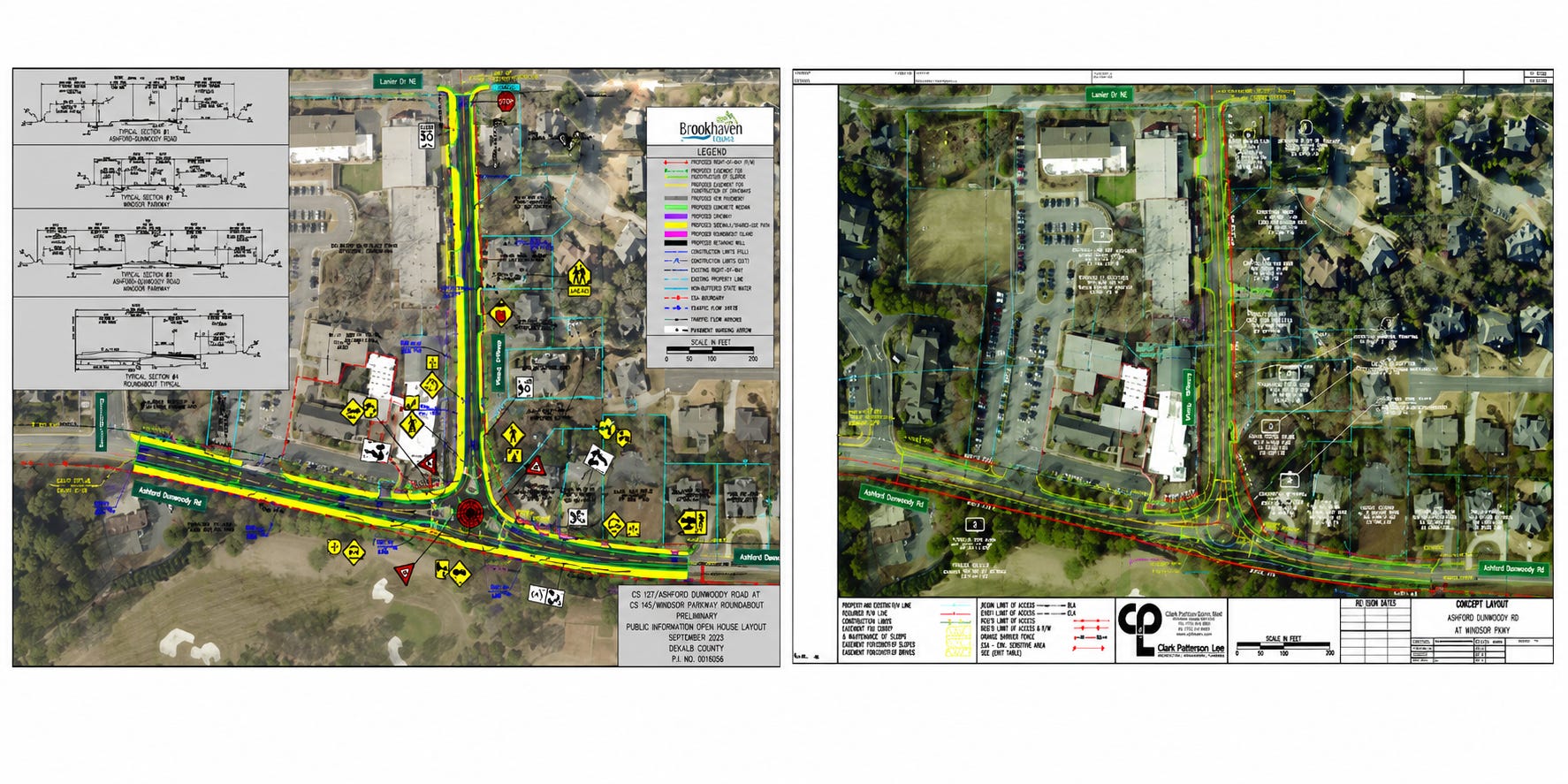
The Original Concept Plan Shows Windsor Parkway Shifting North
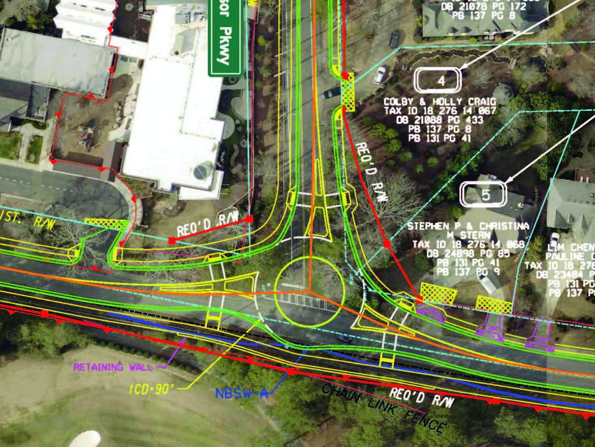
The December 2022 concept layout shows that Windsor Parkway does not remain in its current position while the shared-use path is simply added beside it. The proposed roadway shifts north as it approaches the roundabout, toward the residential properties on that side of the road.
That does not establish why every foot of the shift is necessary, and engineers may be able to adjust part of it. But it complicates the claim that the south-side path alone is solely responsible for the north-side tree and property impacts.
The plan also shows realigned approaches, splitter islands, curb and gutter, retaining-wall areas, required right-of-way, easements, and construction limits. The relevant question is therefore not only how wide the shared-use path is, but how much of the footprint is driven by the roadway geometry, drainage, utilities, grading, and construction access.
The public materials do not yet separate those impacts clearly.
What GDOT Means By “Practical Design”
GDOT’s guidance does not tell designers to maximize pavement or acquire more right-of-way than necessary. Its “practical-design” approach balances safety and operations with cost, right-of-way, utilities, environmental effects, and surrounding context.
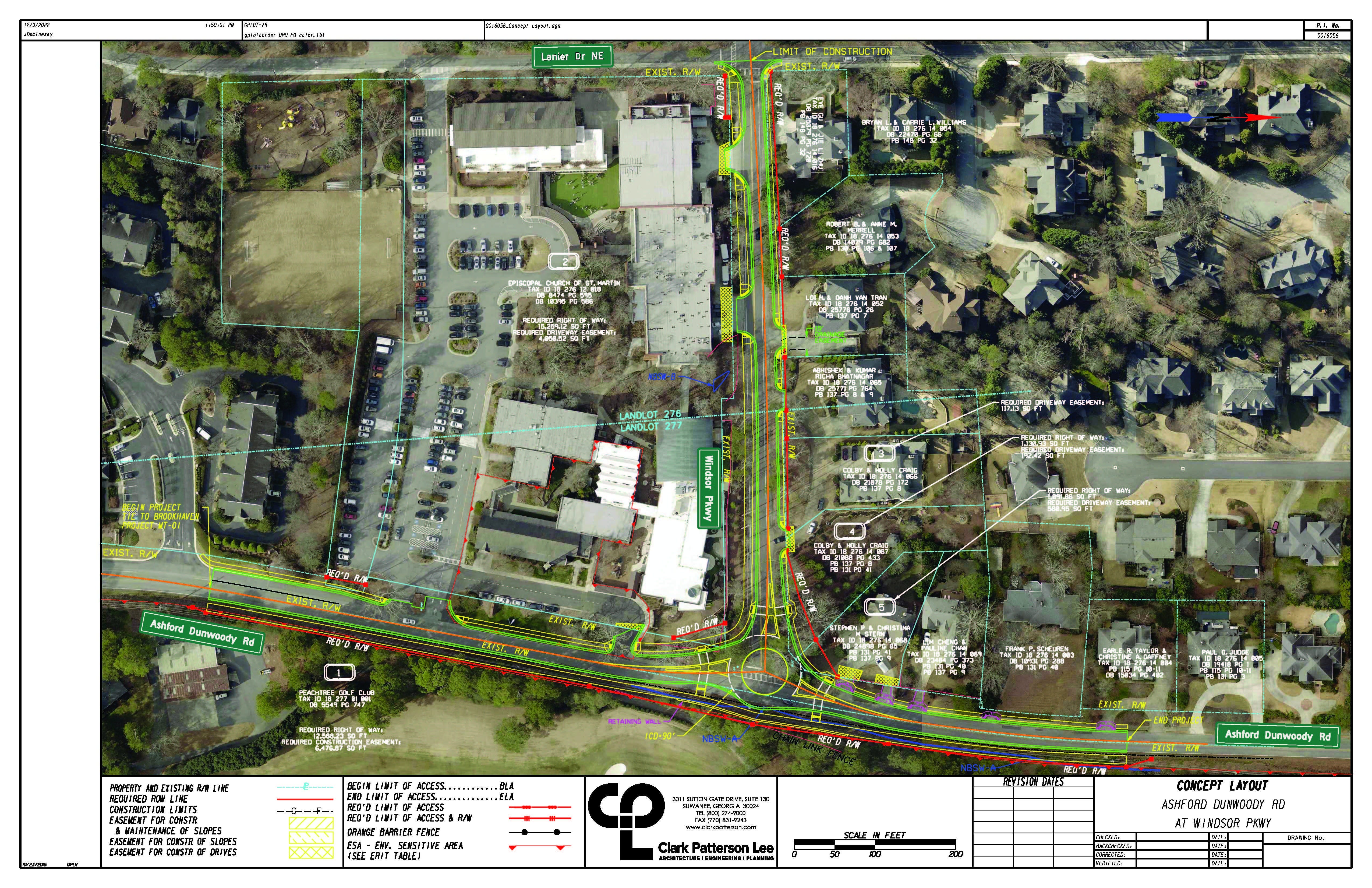
The guide describes compact roundabouts as appropriate when there are “construction cost and right-of-way constraints.” The proposed 90-foot circle is already near the lower end of GDOT’s compact single-lane range, suggesting that further reductions may have to come from the approaches and surrounding cross-section rather than simply shrinking the circle.
The review could therefore examine whether the path can narrow in constrained areas, the roadway shift can be reduced, travel lanes or splitter islands can be tightened, retaining walls can limit grading, or drainage and utilities can be repositioned. Whether any of those changes are feasible here remains an engineering question.
Removing an entire pedestrian or bicycle facility would change what the project provides, not merely how compactly it is built.
The Multimodal Plan Also Points Toward Speed And Lane-Width Changes
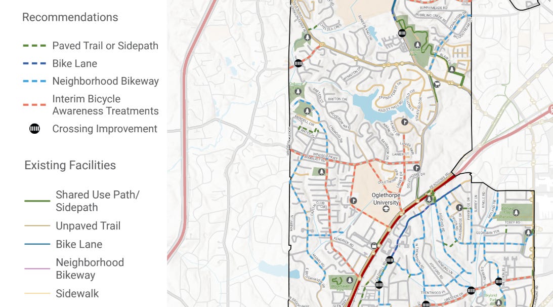
The plan does not direct Brookhaven to lower Windsor Parkway from 30 mph to 25 mph or prescribe 10-foot travel lanes. But it establishes that speed reduction and narrower lanes were already contemplated for this corridor before the current controversy.
That raises two questions for the City and GDOT:
Could the posted or target speed be reduced to 25 mph?
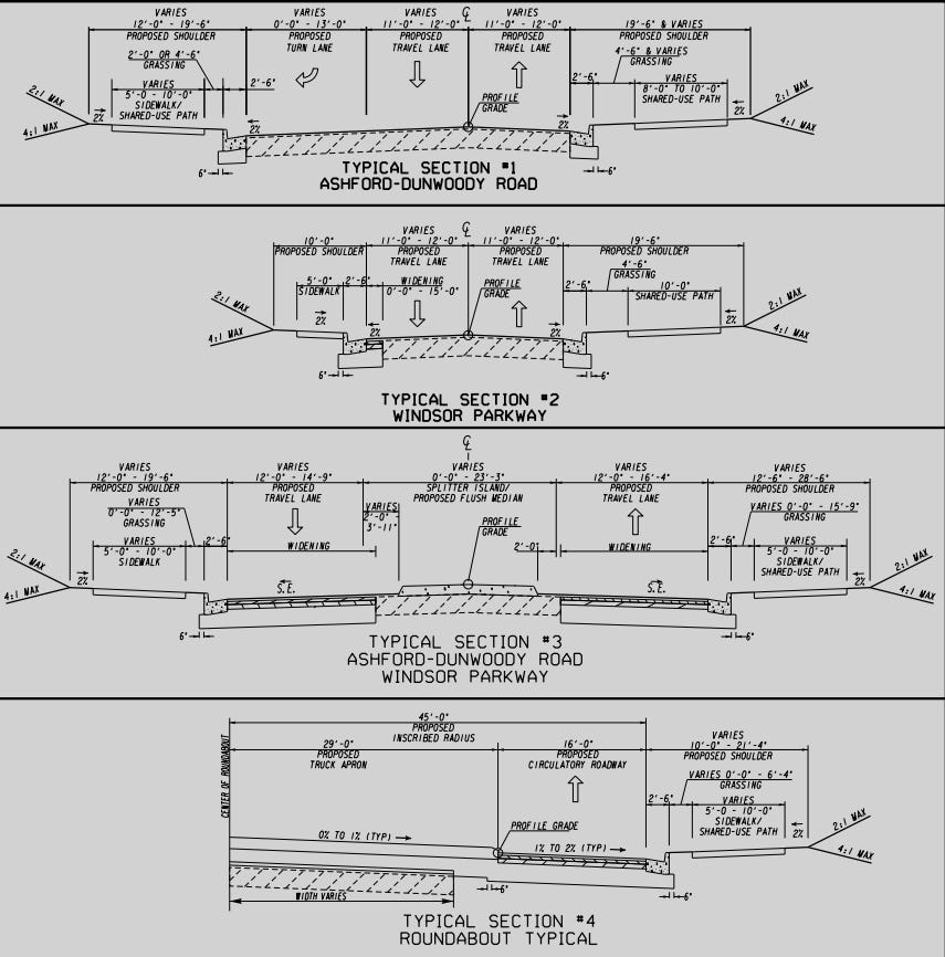
Could the proposed 11- to 12-foot travel lanes narrow toward 10 feet where vehicle tracking permits?
Brookhaven recently repaved and restriped Apple Valley Road with 10-foot lanes. Windsor Parkway has different school-bus, emergency-access, drainage, and roundabout requirements, so the dimensions cannot simply be copied. The comparison nevertheless supports asking whether every proposed lane width is necessary.
A lower-speed, narrower roadway might reduce the footprint and reinforce the roundabout’s traffic-calming purpose. But the Multimodal Study also warns that interim shared-roadway treatments may not be comfortable for every cyclist, which supports retaining an off-road option for children and less-confident riders.
What The Guides Say About Sidewalks, Paths, And Bike Lanes
A 30 MPH Road Does Not Automatically Require A Five-Foot Landscape Buffer
One argument against the shared-use path is that it supposedly requires a large landscape buffer that consumes unnecessary space. GDOT’s Pedestrian and Streetscape Guide provides more flexibility than that.
For sidewalks in urban and suburban curb-and-gutter settings, the guide says a sidewalk:
“may be located immediately behind the curb, or preferably offset from the roadway to improve pedestrian comfort.”
For shared-use paths, GDOT states:
“Shared use paths should be a minimum of 10 feet wide, except constrained shared use paths may be as narrow as 8 feet wide.”
The guide also provides a specific speed threshold for a larger separation:
“On streets with a speed limit of 35 mph or greater, shared use paths should maintain a 5-foot separation from through travel lanes.”
Windsor Parkway is posted at 30 mph, so the guide does not establish that a five-foot separation is required solely because of speed. Engineers must still account for fixed objects, drainage, slopes, visibility, and maintenance, but the language supports examining an eight-foot constrained path or less separation from the curb.
Could Bike Lanes Replace The Shared-Use Path?
Possibly, but the comparison is not as simple as replacing one 10-foot path with two five-foot stripes. Conventional bike lanes would generally be placed on opposite sides of Windsor Parkway, one for each direction of travel, and could affect pavement width, curbs, drainage, trees, the existing north-side sidewalk, and property frontage on both sides.
GDOT’s roundabout guidance is direct about what happens when a bicycle lane reaches the circle:
“A shoulder or bike lane should not be provided within the circulatory roadway.”
The bike lane must end before the yield point; the rider then merges into the vehicle lane or, where available, transitions onto a shared-use path around the roundabout. GDOT also recommends bicycle ramps and shared-use paths to increase comfort for less-experienced cyclists.
That matters here. If the shared-use path were removed in favor of two five-foot bike lanes, riders reaching the roundabout would need to merge into motor-vehicle traffic unless another off-road facility were provided. That may be workable for a confident adult rider, but it is a different design choice for children, families, and less-confident cyclists near a school.
Bike lanes also do not provide pedestrian space. A complete alternative would therefore need two bike lanes, pedestrian accommodation, and safe transitions for riders who will not merge into traffic through the roundabout.
By comparison, the current concept provides a shared-use path on one side and a sidewalk on the other. That may already be the most space-efficient way to provide pedestrian access on both sides and an off-road route for children and less-confident riders — that is an inference rather than an engineering conclusion. The City should test it with a complete cross-section instead of comparing only two five-foot bike lanes with one 10-foot path.
What About Providing No Sidewalk On The South Side?
GDOT does not appear to require sidewalks on both sides of every roundabout approach. But it’s pedestrian guide says that maintaining the “connectivity and usefulness of the overall pedestrian network” should remain a key focus and directs designers to connect destinations through “safe, efficient pedestrian infrastructure.”
The guide also identifies schools as pedestrian generators and calls for accessible crossings, curb ramps, and splitter-island refuge areas. A marked crossing that ends in grass, drainage infrastructure, or an unimproved roadside would be difficult to reconcile with that framework.
A five-foot sidewalk may be a plausible alternative to part of the shared-use path. Providing no south-side pedestrian facility would require a substantially stronger explanation from Brookhaven and GDOT.
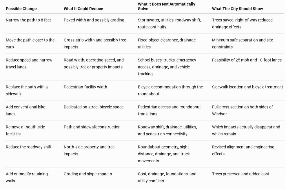
What Each Proposed Change Would Need To Prove
Stormwater And Utilities Also Occupy The Corridor
The City’s infrastructure mapping shows an existing network of stormwater facilities around Windsor Parkway and the St. Martin’s property. The mapped features include catch basins, drop inlets, junction boxes, manholes, headwalls, control structures, and underground connecting pipes.
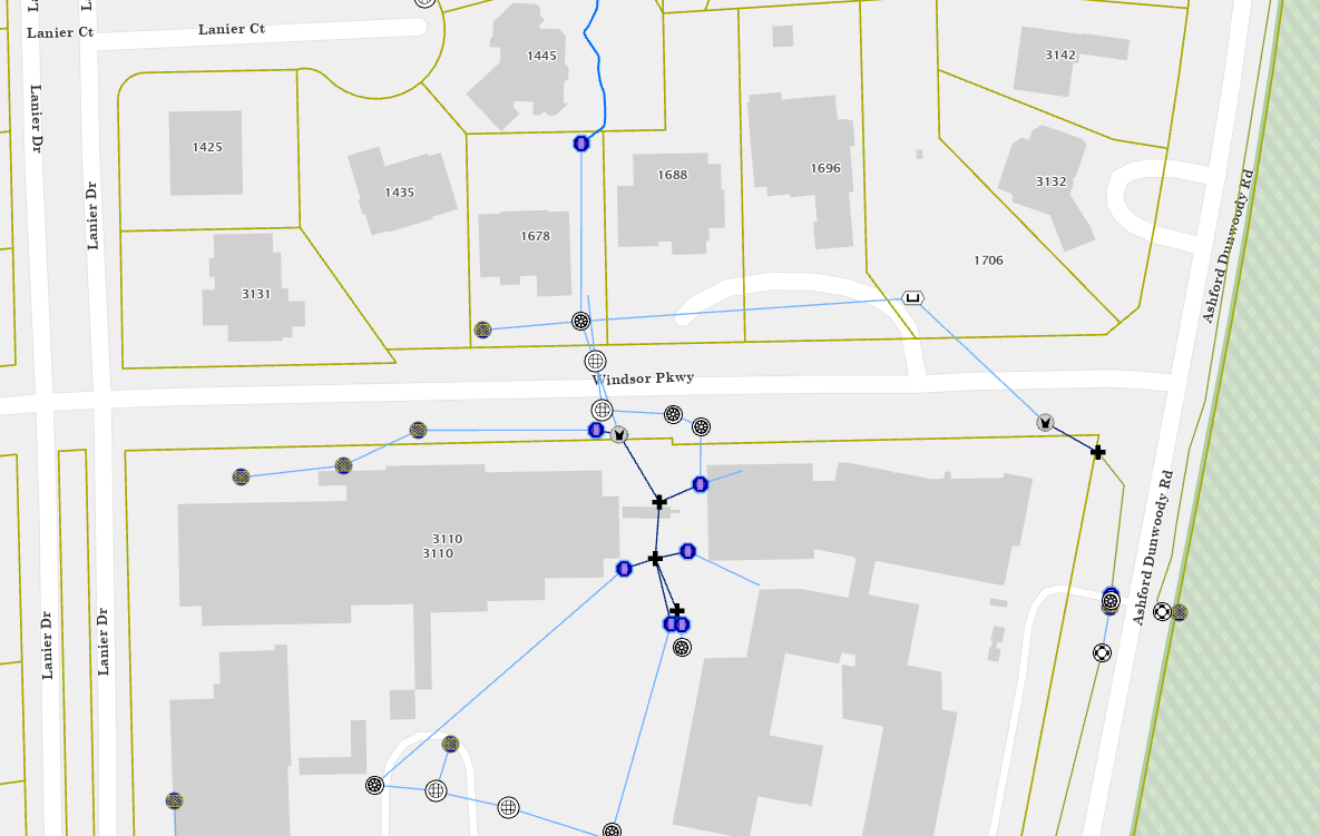
Most of that infrastructure is invisible from the road. A resident may see a curb inlet or metal grate but will not see the underground pipes connecting those structures or the utility corridor carrying water, gas, fiber, electricity, and telecommunications infrastructure.
Road reconstruction commonly requires space for those systems along the roadway shoulder or behind the curb. That makes it unlikely that the shared-use path alone explains every tree, grading, or right-of-way impact.
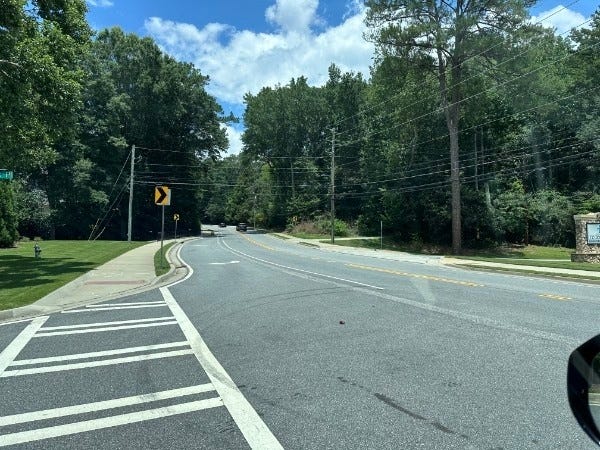
Only the project engineer can quantify how much disturbance would remain under each alternative. But the available utility information indicates that removing the path would not automatically return the corridor to its current condition. The City may still need space for roadway drainage, utility relocation, grading, retaining walls, slope support, and construction access.
Which Trees Would A Redesign Actually Save?
The stormwater and utility maps make one point clear: the shared-use path is not the only project element occupying the corridor. Trees may also be affected by the roadway shift, curb and gutter, drainage structures, grading, retaining walls, utility relocation, or construction access.
That means a tree inside the limits of disturbance is not necessarily standing beneath the finished path. Before accepting or rejecting a redesign, the City should identify which project element affects each significant tree.
The useful question is not whether removing the path saves trees in the abstract. It is which trees would be preserved under each complete alternative—and which would still be affected by the road, drainage, utilities, or grading.
What Right-Of-Way Actually Means
Public right-of-way is land or an easement reserved for transportation and related infrastructure, including roads, sidewalks, drainage, utilities, signs, and lighting. In some locations the government owns the land outright; in others the adjoining owner may retain underlying ownership while the public holds transportation or utility rights.
The legal details vary by parcel, but landscaping and structures inside public right-of-way generally do not have the same protection as improvements located entirely on private property. A fence, irrigation system, mailbox, tree, or planting bed may have existed there for years without preventing the government from later using the area for a lawful road, drainage, utility, or pedestrian project.
That does not make a mature tree environmentally unimportant. The City should still seek to preserve significant trees where engineering allows. But removing a tree within existing right-of-way is different from acquiring new private property to remove one outside that boundary.
The concept plan also distinguishes existing right-of-way from new right-of-way, permanent easements, temporary construction easements, and construction limits. Those categories describe different property and construction impacts and should be explained separately at the town hall.
The Budget Needs The Same Level Of Clarity
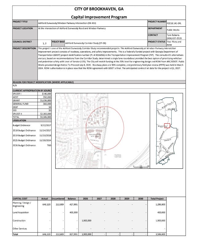
The City’s adopted Capital Improvement Program and its more recent project presentation show different financial pictures.
The adopted CIP lists a $3.5868 million project appropriation, including approximately $1.2868 million for planning and engineering, $400,000 for land acquisition, and $1.9 million for construction.
A later City presentation shows a $7.2337 million current estimate, including $744,600 for preliminary engineering, $3 million for right-of-way, and approximately $3.489 million for construction.
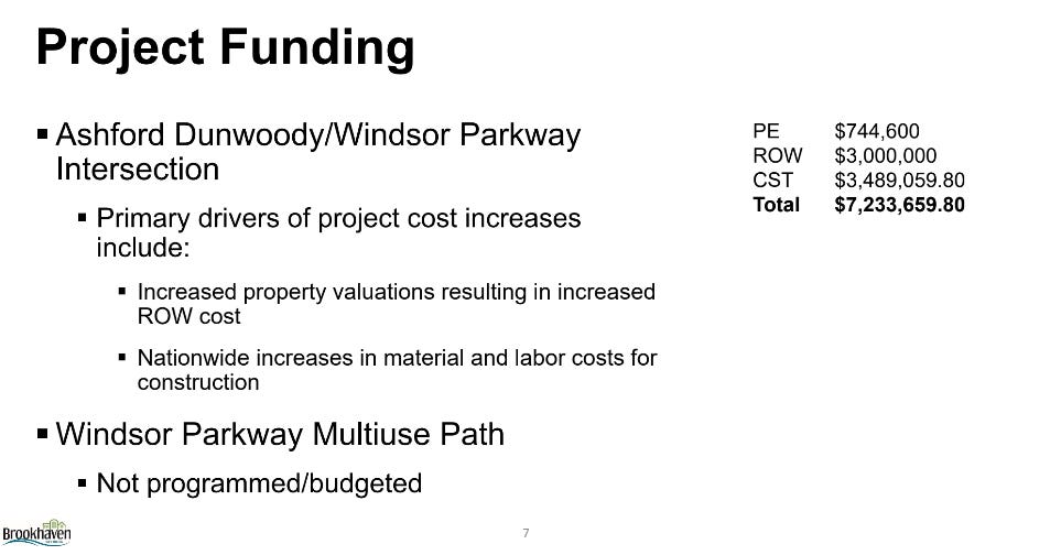
These figures may reflect different dates, funding phases, accounting categories, or stages of development, but they do not reconcile on their face.
The new $2.1 million GDOT construction award creates another unanswered question: Is it additional funding, replacement funding, already included in the revised estimate, or limited to particular costs?
The City should publish one current sources-and-uses table showing total cost, spending to date, each funding source, Brookhaven’s remaining local obligation, and how the new $2.1 million award is applied.
What Brookhaven Should Present At The Town Hall
The town hall should give residents enough information to evaluate the project for themselves, not just another general overview. The most useful presentation would compare the current design with any complete alternatives the City and GDOT consider feasible.
For each option, the City should disclose the physical, financial, and schedule effects in one comparison. That means showing roadway alignment, path and sidewalk dimensions, bicycle transitions, stormwater and utility changes, right-of-way and easements, limits of disturbance, trees removed and preserved, retaining walls, total project cost, Brookhaven’s local share, outside funding retained or lost, redesign time, and expected safety and accessibility effects.
The City should also show whether a 25 mph target or posted speed and narrower travel lanes could reduce the project footprint while remaining compatible with school buses, emergency vehicles, truck movements, drainage, and GDOT’s roundabout performance requirements.
The City should complete a comparison like the one below for every alternative it considers feasible.
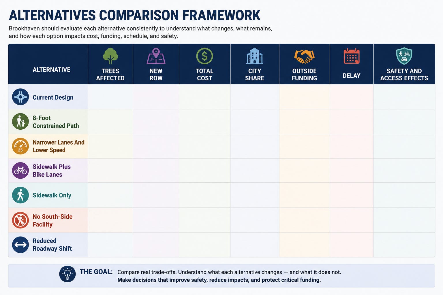
The most important comparison may be the no-path scenario. If the south-side path and sidewalk were removed from the plan, the City should show how much new right-of-way would still be needed, whether Windsor Parkway would still shift north, which drainage and utility work would remain, which trees would still be removed, how pedestrians and cyclists would use the rebuilt intersection, and how the change would affect grants and project eligibility.
That would allow residents to judge the tradeoff rather than infer it.
GDOT may identify narrower path sections, reduced curb separation, narrower travel lanes, less grading, shorter splitter islands, retaining walls, utility coordination, or roadway-alignment changes. Engineers may also determine that some requested changes conflict with drainage, sight distance, vehicle movements, pedestrian access, federal requirements, or outside funding. The public should see that analysis before being asked to accept either conclusion.
Where This Leaves The Project
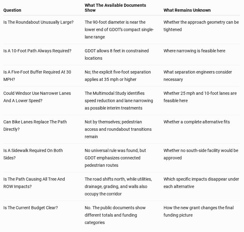
These findings do not predict what GDOT will approve; they identify what the available documents establish and what Brookhaven still needs to explain.
My Personal Take
The town hall will only be useful if supporters and opponents come prepared to listen, ask questions, and allow new information to affect their positions. Residents should hear what the tree inventory shows, what GDOT considers feasible, what drainage and utility work still requires space, what each alternative costs, and whether a change would affect safety, schedule, or outside funding.
People are entitled to organize and advocate for a preferred outcome, but if the only acceptable result is removing every project element that affects a particular property, then the purpose of the pause has already been lost. A public review should test alternatives against evidence, not merely confirm positions taken before the engineering information is presented.
I plan to attend willing to listen and learn. I am hopeful that Brookhaven and GDOT can identify meaningful refinements, even if some changes only save inches rather than feet; small adjustments could still preserve trees, reduce grading, or lessen property impacts.
My underlying position remains the same: the project should retain its original purpose of improving safety for people driving, walking, biking, rolling, or using mobility devices.
I want the City to identify every reasonable opportunity to preserve native and mature trees, but not by transferring risk to pedestrians, children, cyclists, or drivers—or by jeopardizing substantial outside funding without first explaining the consequences.
The town hall should give residents enough information to evaluate the project for themselves rather than simply repeating a general project overview. It should be an opportunity to understand the constraints, compare real alternatives, and decide whether the project can be improved without giving up the safety benefits residents have waited years to receive.